You can now download flights using BreadCrumbs into a GPX format.
When importing the GPX file into Google Earth, please use the following settings.
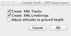

You can now download flights using BreadCrumbs into a GPX format.
When importing the GPX file into Google Earth, please use the following settings.
Enjoy
Next release is June 27
However, FAA forgot to include the Honolulu TAC, if it eventually shows up I’ll include it. The next chart update is May 30.
The next release is May 2nd – please see other release dates here.
With the new SUA info, if you notice any problems please let me know. Please look up the next chart cycle here.
FAA changed one of their data files to a new format. Please let me know if you are missing anything.
Now with easier to select Chart types, and a better help when entering routes.


Enjoy
Three NEW geo-referenced charts for Helicopter pilots!
Besides the Heli chart itself you also get the Gulf Of Mexico and Gulf Coast WAC charts. The app also includes the VFR,TAC&FLY charts, as well as the Low Enroute IFR charts.
You also get ALL approach plates, A/FD information, published NOTAM, SUA info and Chart Legends for VFR,IFR&TPP (Terminal Procedures Publication).
AppStore link here.
This is what the new charts look like, please check out the other screen shots.


Enjoy